Saturday 13 October 2007
Thursday 20 September 2007
Interactive Water Cycle

Wednesday 19 September 2007

River Processes
As a river flows along its course it undertakes 3 main processes which together help to shape the river channel and the surrounding valley. These processes are erosion, transport and deposition.
RIVER EROSION
River erosion is the wearing away of the land as the water flows past the bed and banks. There are four main types of river erosion. These are:
Attrition - occurs as rocks bang against each other gradually breaking each other down (rocks become smaller and less angular as attrition occurs)
Abrasion - this is the scraping away of the bed and banks by material transported by the river
Solution - chemicals in the river dissolve minerals in the rocks in the bed and bank, carrying them away in solution.
Hydraulic Action - this is where the water in the river compresses air in cracks in the bed and banks. This results in increased pressure caused by the compression of air, mini 'explosions' are caused as the pressure is then released gradually forcing apart parts of the bed and banks.
Watch this animation to see these processes in action.
RIVER TRANSPORT
Material may be transported by a river in four main ways: solution, suspension, saltation and traction (see diagram). The type of transport taking place depends on (i) the size of the sediment and (ii) the amount of energy that is available to undertake the transport. In the upper course of the river there is more traction and saltation going on due to the large size of the bedload, as a river enters its middle and lower course there is alot of finer material eroded from further upstream which will be carred in suspension. Watch this animation to recap the 4 types of transportation.
DEPOSITION
Deposition is where material carried by the river is dropped. This will occur when there is no longer sufficient energy to transport material. Deposition of material may result in the formation of distinctive features such as slip off slopes (on the inner bends of meanders); levees (raised banks) and of course the floodplain itself. Remember - it is the largest material that will be dropped first as it requires the most energy to be transported. eroded from further upstream which will be carried in suspension. This animation shows sediment deposition as a river enters a lake - look at what size material is deposited first.
Now test your understanding:Try out these drag and drop games to match up the key processes of erosion and transport with their correct definitions.
River Erosion drag and drop
River Transport drag and drop
Wednesday 29 August 2007
Rocks rock!
Monday 25 June 2007
Section 11: Evaluation
1. How did you collect your data?
- Was this successful?
- Did it tell you what you needed to know?
- Was there any bias in your data collection? Maybe you collected some of it on a sunny day and some of it on a rainy day, or perhaps your sampling methods weren't very well planned (see previous post on this).
- Was any of your data unrealiable? Maybe you could only find out of date information or had to use an old map etc.
2. How would you improve your project if you did it again?
- Was there one part of your coursework that you think lets it down? (maybe the analysis, the data collection or the original hypotheses)
- What could you do to improve this?
3. What could you do to extend your study?
- Maybe you could investigate another hypothesis
- Or you could use an additional method of data collection to find out more information about one element of your work?
Read this document for some more detail.
Section 10: Conclusion
In this section you need to give a clear overview of what you have discovered about your neighbourhood, especially focusing on your hypotheses.
- Say what your hypotheses were
- For each, say whether you found them to be true or false
- And refer to what evidence you have to back this up.
There is some example work on the G drive.
Section 9: How does my neighbourhood compare with others?
Again, this section comes in 2 parts:
1. Compare your neighbourhood with another neighbourhood
- Find a friend who has done environmental quality surveys in a different part of Long Eaton.
- Swap environmental quality surveys with them.
- Make sure you include a map to show the location of the 2 neighbourhoods.
- Compare the information that your friend has collected with the information that you collected - you could present this information as graphs.
- Describe what the data tells you about the two neighbourhoods - are they very similar or very different? Do they have some common features e.g. parking problems, or good street lighting.
2. How does your neighbourhood compare with models of land use?
- You should compare your neighbourhood with land use models like Burgess or Mann.
- The Burgess model suggests that environmental quality should improve the further you travel from the CBD.
- Where does your neighbourhood fit into this model?
- There is some information about land use models on the G drive.

Section 8: Improving my neighbourhood
- some run down or empty buildings
- a park that is neglected
- some waste land or open space that could be put to better use
- a lack of services in your neighbourhood
- litter / vandalism / lack of street lighting
You should describe:
1. What the problem is - including a map and some labelled photographs
2. What you would do to improve the area - you could be really creative here - design a plan of what it will look like (you can do this by hand); include some images from the Internet of similar designs / services etc;
Sunday 24 June 2007
Traffic counts
Traffic Counts
You could use the results of this survey in section 7: Describing my neighbourhood.
Friday 22 June 2007
Sampling Methods
Wednesday 20 June 2007
New coursework deadline
Friday 6th July 2007
This is to take account of the fact that you have had exams, as well as coursework in other subjects due in around the same time. This is a final deadline and will not be moved again. You go on work experience the following week, so aim to have your coursework complete and ready to hand in on or before that date!
Section 7: Describing my neighbourhood
a) Describing my neighbourhood
Some general information about your neighbourhood using data you have collected from surveys. You should be aiming to include information from at least 3 of these – types of houses, age of houses, litter, vandalism, noise pollution, traffic problems, environmental quality etc.
b) Testing my hypotheses
For each of your hypotheses you should show what evidence you have collected and explain what this shows about your neighbourhood. Finally, have you shown your hypothesis to be true or false (it is fine to say that it was wrong!)
Make sure this section is well structured, with sub-headings and thorough explanations of all graphs, photographs etc. You should include a range of data such as maps, graphs, tables, photographs etc. The more data the merrier – as long as you explain it thoroughly!! There are some examples of how you could present this work on the G drive – in Geog coursework folder called ‘Student work’.
Monday 11 June 2007
Y10 Exam revision
Question 1: World cities and LEDCs
Question 2: Settlement and OS map skills
Question 3: Economic Activities
Use this powerpoint to guide your revision
Case study of Linby
Wednesday 23 May 2007
Defining where 'My Neighbourbood' is
Collecting data
 Your main aim during half-term is to get your primary data collected. This could include:
- surveys
- photographs
- traffic counts
- environmental quality surveys
Everyone should complete an environmental quality survey for each street in their neighbourhood. Lost the sheet? No excuses ... download a new one here!
There are also many other methods and types of data that you could collect - look here for some ideas:
Coursework Guidance
Remember, there will be no school network over half-term!
Coursework Guidance - the definitive guide on what to include!
Sunday 13 May 2007
Setting the Scene
 AN INTRODUCTION TO LONG EATON
In this section, write about the town of Long Eaton to tell the person reading your work what the town is like.
· A map to show the location of Long Eaton in the UK and the Midlands.
· A description of Long Eaton’s location
· Size of population
· A little bit of history about Long Eaton
· Services and recreation facilities in Long Eaton
· Types of businesses and work places in Long Eaton – can you name any companies?
· Local communications and transport (roads, air port, public transport)
· One or two photographs of something well known in Long Eaton?(not too large though)
 HEALTH WARNING!
Background
You need to write a paragraph to put your work ‘in context’. This means explaining why it is useful to study towns and cities and how people live in them…………… So, you could explain that most people do live in urban areas, so there must be some good reasons why. Say what you think these reasons are.
Setting Your Aims
• To describe and explain the features of my neighbourhood.
Now write a brief paragraph about what your neighbourhood is like and how you will investigate it (such as, by collecting and analysing primary and secondary data).
• To investigate 3 hypotheses about my neighbourhood.
Write them down in a list (have a look at the sheet that has some examples of hypotheses).
• To investigate a local environmental issue (or problem) in my local area and suggest how this issue (or problem) can be solved or improved.
Now briefly say where the local issue is and what the local issue (or problem) is.
This document shows how you could set out this section:
Beginning your Coursework
General advice:
- This is YOUR (!) coursework and it is up to you to set yourself goals and targets for what you want to achieve.
- You have a word limit of 2500 - 3000 words.
- The deadline is Friday 22nd June.
- Your coursework is about your neighbourhood - this is an area of between 7 and 10 streets surrounding your house.
- Your work should be presented professionally and everything should be word processed.
- All maps, graphs and photographs should have titles and labels where appropriate.
Finally, you could try to enjoy it!
Wednesday 9 May 2007
Things I found on You Tube
Monday 7 May 2007
Two approaches to tourism in Brazil
Sustainable tourism is tourism that does not damage culture or environment and improves the lives of those involved in it.
The Ariau Towers Hotel

Visit the website here to see what type of tourism goes on here.
The Mamiraua Tourist Project

Visit this website to see details of holidays in the floating lodges!
Access this information sheet with key details of the two very different holiday destinations in Brazil.
Tuesday 1 May 2007
Newly Industrialised Countries (NICs)
View this slideshow to see the effects of rapid industrialisation on NICs such as Thailand.
Monday 30 April 2007
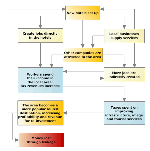
Tourism - blessing or curse?
The Multilpier Effect demonatrates how tourism can help economies to develop e.g.
New hotel built
Tourists come
Tourists spend money
More jobs created. Local shops and businesses make more money
Spending power of local people increases
Leisure facilities developed
New airport and water and electricity facilities improve
Transport facilities improved
More hotels built
More tourists come
But, tourism can also cause problems for people living in LEDCs. Some of these problems are on this sheet.
Spot the difference between a mass tourist and a sustainable tourist here:
Homework question
Many LEDCs have used tourism as a way of developing their economy.
1. Name an LEDC you have studied where tourism has been used as a route to development.
2. Describe the positive and negative effects of the development of tourism on the quality of life for people living there.
3. Overall, so you think tourism has benefited your chosen country?
Tourism in an MEDC
 Using Benidorm as a case study, you will look into tourism in an MEDC and the cycle that it has followed.
TNCs in LEDCs
TNCs (or Transnational Corporations) are large companies which which have offices or factories in several countries and are global because they operate across national boundaries. Examples of TNCs include Nike, Wal-mart, Microsoft, BP, McDonald's and many many more.
Why do they choose to locate in LEDCs?
Most TNCs have their headquarters in MEDCs such as Nike who ares based in Oregon in the USA. However, many TNCs are now choosing to locate branches in LEDCs - why is this? All we need to do is compare the average wages of people in different countries to see why this might be!
TNCs can be huge! Some make more money in a year than some countries do! They often find that by choosing the locate in LEDCs, they can;
(a) manufacture goods for sale more cheaply and,
(b) be near to large markets (places with large populations where goods can be sold).
Are TNCs good or bad?
There are a number of advantages and disadvantages to LEDCs of having a TNC locate in their country. You can download this list as a Word document by using the control below.
Homework question
To what extent can investment from TNCs help LEDCs to develop?
